The home of Australian Boulder Opal
Queensland produces boulder opal, an unique type of opal which is found attached to a host rock, ironstone. Boulder opal is unique to Queensland, and occurs in deposits in weathered sedimentary Cretaceous rocks in the west of the state.
Much opal mining in Queensland is carried out in ‘open cut’ mining operations, which is vastly different to shaft mining.
The Queensland opal fields are within a belt of deeply weathered Cretaceous sedimentary rocks known as the Winton Formation, which extends in a north-westerly direction from the New South Wales border at Hungerford stretching west of Cunnamulla, Quilpie, Longreach and Winton to Kynuna, a distance of about 1000 km.

Queensland’s opal mining fields are located in the west and southwest of the State, and include:
Yowah field (the southernmost field centred on the small town of Yowah—includes Black Gate)
Koroit field (north-east of Yowah)
Toompine field (east and south-east of Toompine—includes Lushingtons, Coparella, Duck Creek, Sheep Station Creek and Emu Creek)
Quilpie field (west and north north-west of Quilpie—includes some of the more productive mines in recent times—Pinkilla, Bull Creek, Harlequin, and probably the most famous of all, the Hayricks.
Kyabra-Eromanga field (west and north-west of Eromanga)
Bulgroo field (north of Quilpie field in the Cheviot Range—includes the Bulgroo, or Germans—and Budgerigar to the north )
Yaraka field—includes the mines in the Macedon Range, such as Mount Tighe
Jundah field (west of Jundah over the Thompson River—includes Jundah and Opalville mines)
Opalton-Mayneside field (centred on the old abandoned township of Opalton, and to the south in the Horse Creek – Mount Vergemont area)
Kynuna field—the most northerly field, south of the township of Kynuna.
Boulder opal is widely distributed in rocks in these areas, in generally elongated or ellipsoidal siliceous ironstone concretions or boulders ranging in size from less than a few centimetres to more than 20 cm. Concretions up to 5 cm across, known as ‘nuts’, may host a kernel of solid opal or contain a network of thin veins of opal through the ironstone. This variety of opal is prevalent at Yowah where the concretions form distinct bands—the well known ‘Yowah-nuts’.
These opal fields lie within a 300 km-wide belt of deeply weathered Cretaceous sedimentary rocks known as the Winton Formation. This extends north-north-west from Hungerford on the New South Wales border, west of the townships of Cunnamulla, Quilpie, Longreach and Winton, to Kynuna, a distance of about 1000 km.
Boulder opal is widely distributed in rocks in these areas, in generally elongated or ellipsoidal ironstone concretions or boulders, from a few centimetres, to up to 3 m across. The boulders may be confined to one or more layers or randomly distributed through the weathered sandstone. Their composition ranges from sandstone types (a rim or crust of ferruginised sandstone surrounding a sandstone core) or ironstone types (composed almost entirely of iron oxides).
The opal occurs as a filling or lining between the concentric layers or in radial or random cracks in the ironstone, or as a kernel in smaller concretions or nuts. (as found at Yowah and Koroit fields, the famous ‘Yowah-nuts’). Matrix opal is where the opal occurs as a network of veins or infilling of voids or between grains of the host rock (ferruginous sandstone or ironstone). Rare seam or band opal is also found and is typically encased in ironstone.
Pipe opal occurs in pipe-like structures which may be up to several centimetres in diameter within the sandstone and these structures may be hollow or opal-filled. Wood opal is occasionally found replacing woody tissue material.
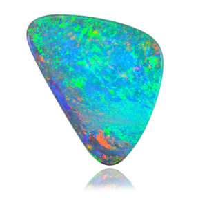
As opposed to other sedimentary precious opal, boulder opal is attached to the ironstone, and stones are usually cut with the natural ironstone backing intact. Solid opals may be cut from the ironstone material where the opal is of sufficient thickness. Boulder opals are fashioned to standard shapes and sizes but are also cut in freeform shapes to highlight their individual beauty and to avoid wastage. Magnificent picture stones are also cut but these are mainly of interest to collectors rather than for jewellery use.

Looking for colour? In these parts there’s plenty of it, to be found both in the stories relating to the early settlement of the region and also that ‘colour’ which is sought from beneath the surface of the bush earth. Quilpie is best known as an opal town. It is often referred to as the home of the ‘Boulder Opal’ as the area is the largest producer of this type of opal in the world.
Located 980 kilometres west of Brisbane and 208 kilometres west of Charleville, Quilpie is the commercial and social centre of the Quilpie Shire. The name of the town was derived from the Aboriginal word ‘Quilpeta’ meaning Stone Curlew.
Relatively young, Quilpie was declared an official town on 29 April 1917, in the same year the railway line from Charleville to Quilpie was completed. Quilpie is rich in grazing history beginning with the pioneering efforts of families such as the Costello’s, Tully’s and Duracks.
Quilpie is located on the banks of the Bullo River in the famous Channel Country of western Queensland. The shire is supported through primary industries such as sheep, cattle grazing, oil, gas and opal mining. Apart from these main industries Quilpie Shire houses a keen and talented artistic community.
Rich in history, Winton was originally known as Pelican Waterhole and was first settled in 1875. The town is best known as the place that Banjo Paterson wrote Waltzing Matilda in 1895, whilst at Dagworth Station outside Winton. The first performance of the ballad was reported to be at Winton’s North Gregory Hotel on the 6th of April of the same year. Winton is recognised as the ‘home’ of Australian bush poetry, hosting the annual Bronze Swagman Award, one of the country’s most prestigious literary awards.
Queensland and Northern Territory Aerial Service (Qantas), Australia’s national airline was formed in Winton in November, 1920 and its first board meeting was held in the Winton Club on 21st February 1921.
During the Great Shearers’ Strike in the 1890s, 500 shearers camped just south of Winton and the town was placed under marshal law. This was the beginning of the foundation of the Labor Party.
Winton is famous for its water supply which thrusts its way to the earth’s surface from three artesian bores, all around 1,200 metres deep emerging at a temperature of 83 degrees celsius. The water is sourced from the Great Artesian Basin which provides water for most of Australia’s outback.
Winton is in the centre of Matilda Country, a diverse region in which vast mitchell grass plains are broken by magnificent coloured gorges, ridges and jump-ups. Visitors to the region will be amazed by the vastness of the plains and the undulating nature of the landscape. There is a wide variety of animal and bird life in the area, generally best seen around dusk and dawn on minor roads and tracks.
Day trips from Winton take visitors to Opalton, one of the oldest opal fields in Queensland; Combo Waterhole, where the swaggie of ‘Waltzing Matilda’ fame reputedly met his fate; the vintage sandstone homestead of Old Cork Station; and Lark Quarry, where 93 million year-old fossils capture a dinosaur stampede.
The Opalton Field, also called the Fermoy Field was one of the largest and most extensively worked opal deposits in Queensland. It is a good example of typical opal country in western Queensland and offers the visitor the opportunity to experience first hand the remoteness and harsh conditions endured by the opal miners. Mining activity on the field is mostly limited to small-scale hand mining but some larger operations using heavy machinery are present in the surrounding area.
The Opalton Designated Fossicking Land was established in 1995 under the Fossicking Act 1994 by the then Department of Mines and Energy, with the co-operation of the Winton Shire Council and the landholder to provide for tourist and recreational fossicking. The Opalton Field is located about 124 km by road south-southwest of Winton. Travelling from Winton take the Jundah Road (mostly unsealed) and travel 15 km, turn left and travel a further 109 km (unsealed road) past Weona Homestead to Opalton. Visitors are requested not to call at ‘Weona’.
The Opalton area attracts large numbers of visitors and is popular with tourists as a place to “speck” or”noodle” fragments of opal or ironstone matrix from the surface or from the spoil dumps of old workings. However, known areas of shallow ground, such as the old Brilliant Claim area, may offer the more serious fossicker a chance to dig and find that outstanding gem.
The Yowah opal field which includes the nearby area known as Black Gate is the southern-most opal mining centre of western Queensland. It is popular with tourists and fossickers as it has easy access from main roads and has shops, fuel, telephone, caravan park, and a permanent bore water supply. A small local population increases significantly during the winter season. The Yowah Fossicking Area has been established by the Department of Mines and Energy with the co-operation of the Council of the Shire of Paroo and the landholder to provide for tourist and recreational fossicking.
Yowah is about 160km west of Cunnamulla. Travelling towards Thargomindah, turn off to the right about 18km west of Eulo onto the Yowah / Toompine road and travel 48km via Alroy homestead to the Yowah-Quilpie turnoff. Continue a further 23km to Yowah; this last 23 km is unsealed. From Quilpie, drive 110km through Toompine to the Eulo / Yowah turnoff. Turn left and follow this mainly unsealed road for about 56km to the Yowah turnoff, and then continue the further 23km as above.
A feature of the Yowah field is the occurrence of precious opal in siliceous ironstone nodules generally referred to as “Yowah Nuts”. These nuts range from about 5mm to 200mm across, have a spherical or ellipsoidal shape, and show alternate concentric rings or bands of light and dark brown siliceous ironstone. There is sometimes a kernel of precious opal which is the main source of the gem. The nuts are found in layers (150 to 600mm in thickness) at depths up to 20m in a ferruginous sandstone, and are commonly associated with mudstone fragments or clay pellets. The main layer is located near the contact between the sandstone and underlying mudstone / claystone, but scattered nodules, and in some cases a second band, may occur above. The lateral continuity of the nut bands is somewhat difficult to predict owing to the irregular bedding of the strata, as well as the lack of any detailed
mapping. In some shafts, the nut band was not encountered, but the sandstone at its contact with the mudstone was found to be more ferruginous and cemented by partial opalisation into a hard band, which also contained opal in the form of seams and pipes.
The eastern part of the Fossicking Area has always been popular with tourists as a place to “speck” or “noodle” fragments of opal or ironstone matrix from the surface or shallow depth. In this area the main nut band appears to have been exposed at the surface, so that a layer of loose rubble of broken ironstone nut fragments covers the surface to a depth of about 600mm. Spotting chips of opal or fragments of matrix while digging through this
material is relatively easy with a bit of practice. Fragments may also occur on the spoil heaps of shafts from the old mining activities.
Opals from Queensland
Sources :
“Opal in South Australia”, Mines & Energy Resources, SA
“Opal”, Qld Dept. of Mines & Energy